


:

micheljullien
User
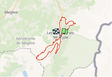

Length
36 km

Max alt
1995 m

Uphill gradient
1757 m
Km-Effort
60 km

Min alt
1001 m

Downhill gradient
1758 m
Boucle
Yes
Creation date :
2025-07-23 09:28:00.426
Updated on :
2025-07-23 13:52:08.446
3h31
Difficulty : Very difficult

FREE GPS app for hiking
 SityTrail
IGN / Geographical institutes
SityTrail Plus
The world is yours!
About
Trail Mountain bike of 36 km to be discovered at Auvergne-Rhône-Alpes, Upper Savoy, Les Contamines-Montjoie. This trail is proposed by micheljullien.
Description
Contamines-col du Joly-col de Truc réel
Positioning
Country:
France
Region :
Auvergne-Rhône-Alpes
Department/Province :
Upper Savoy
Municipality :
Les Contamines-Montjoie
Location:
Unknown
Start:(Dec)
Start:(UTM)
323426 ; 5076137 (32T) N.
Comments